ALPECOLE
_
Snow and perennial ice

Ice formation and firn facies


Gorner- and Grenzgletscher

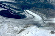
1 - Gorner- and Grenzgletscher showing a polythermal glacier with a cold accumulation area (76K)

The formation of a glacier depends mainly on winter precipitation. This precipitation has to be great enough for some of the snow to last throughout the following summer. This sequence must be repeated for several successive years, until finally, under the pressure of its own weight the snow turns to ice. If this ice layer is thick enough, it can flow under the influence of gravity. This transformation of snow to ice is often a long and complex process, both its nature and the time involved depend on ambient temperature and the depth of further, overlying snow. Changes take place fastest in temperate regions, like the Alps and slowest in the polar regions, like the Canadian Arctic, because of the higher temperatures in the former.

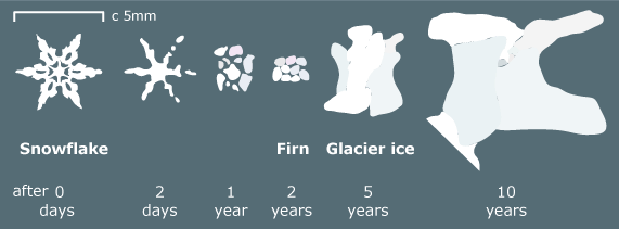
The transformation from snow to ice follows a process chain: Snow crystals have a hexagonal structure with characteristic six-sided symmetry; snow falls in myriad forms. First the fragile crystals break on settling, as they break down if they become wet. Gradually, snowflakes change to grains which become rounded and granular, like coarse sugar. As the snow becomes compressed it becomes harder and denser. At first the air spaces between grains are connected, but now the snow is said to have turned into firn; this is an intermediate stage in its transformation to ice. The firn stage is generally reached after one complete annual cycle, when the snow density approaches half that of water. As these changes proceed, the relatively round grains of firn begin to recrystallise and large ice crystals of ice begin to form at the expense of their smaller neighbours. Air is now only present as bubbles trapped inside the growing crystals.

2 - Transformation from snow to ice.
Source: Glaciers by Hambrey and Alean

Compare this process with the metamorphosis process of snow crystals.

transformation from snow to ice


Glaciers can be roughly classified into different zones. Do you know these zones?

Act

Drag the names on the right side into the corresponding field. If you need additional information about these zones see the table below.

A classification was first proposed by Shumskii (1964) and Benson (1961)


Glacier zones
ablation area This area is below the equilibrium line where loss of ice occurs through calving, melting or evaporation. In this area of a glacier more glacier mass is lost than gained.
accumulation area The snowfields or cirques of mountain glaciers and the snowfields of continental glaciers are called the zone of accumulation because it is here than new snow falls to nourish the glacier. In this area of a glacier more mass is gained than lost.
cold infiltration zone (or wet snow zone): In this zone, by the end of the summer, the temperature of all the snow deposited since the end of the previous summer has been raised to 0°C. Some melt water also percolates into deeper layers formed from precipitation in previous years, though not necessarily in sufficient quantity to raise the temperature of these layers to 0°C. The firn temperature is around 0 to –10°C. Large parts of the subarctic accumulation areas and alpine summits above 4000 m belong to this zone.
equilibrium line This is the boundary between the accumulation area and ablation area where the mass balance is zero.
recrystallisation zone (or dry snow zone) No melting occurs, even in summer. The firn temperature at the Zero Annual Amplitude (ZAA) (at a depth of c. 15 m) is about equal to the Mean Annual Air Temperature (MAAT) (c. –15 to –20°C). The accumulation is low (only a few centimeters to decimeters of water equivalent per year). The firn/ice border is situated at a depth of around 50 to 100m. Such areas can be found in Antarctica, in the center of Greenland and in high altitudes like the summits of Mt. Mc. Kinley and Mont Blanc.
recrystallisation-infiltration zone (or percolation zone) Some surface melting occurs in this zone. Water can percolate a certain distance into snow at temperatures below 0°C before it refreezes. If the water encounters a relatively impermeable layer it may spread out laterally. When it refreezes an ice layer or an ice lens is formed. The firn temperature at the ZAA is clearly higher than the MAAT (c. –10 to –20°C). The accumulation is somewhat higher than in the recrystallisation zone. The firn/ice border is situated at a depth of around 30 to 50m. These zones can be found in areas close to the poles and on higher summits (e.g. Monte Rosa).
snow line This line marks the minimum elevation of snow lying on the ground or glacier surface.
The snow line at the end of an ablation season marks a glacier's current equilibrium line.
superimposed ice zone In dry areas between the firn line and the equilibrium line (mass balance = 0) a broad area, called superimposed ice zone (or infiltration-congelation zone), is situated.
warm infiltration zone (temperate firn) In this zone melt water can leave the firn (mass loss). The firn temperature is around 0°C. The firn/ice border is situated at a depth of around 20 to 30m. Temperate firn is typical for maritime mountain areas with altitudes between 3000 and 4000 m.


upback to topup

29 August 2011
© ALPECOLe 2002-2007