 |
|
|
|
|
|
|
Individual falling pieces of rock usually reach runout distances which correspondiing to a 25-30° slope of the trajectory. Cumulative events build up scree slopes and fans of corresponding surface slope (Figure 1). Systematic grain-size sorting can often be observed with larger blocks move farther than fine material (sand, silt), because of reduced friction along partial paths in air. Quantitative models involve |
|
1 - Rock fall in the year 1991 at Randa Mattertal, Valais, Switzerland. The rock fall occurred in two events. |
|
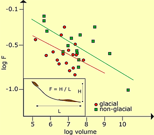
One major unsolved problem in vegetation-free areas, as they are characteristically found in periglacial mountain belts, concerns the destruction of falling/jumping rock particles. Larger volumes of destabilized rocks are much less frequent but can reach far greater distances with much lower inclinations of the trajectory, especially on glaciers (Figure 2). The latter effect is due to:
|
2 - Relation between average slope and the corresponding catchment area of 82 debris flows in the summer of 1987 in Switzerland. |
| |
|
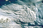
Cumulative deformation results from the steady-state creep of perennially frozen talus or morainic material rich in ice. This movement leads to the formation of striking lavastream-like landforms traditionally called rock glaciers (Figure 3). Such features clearly indicate the present or former existence of ice-rich frozen ground. Here, reduced internal (particle-to-particle) friction and ice-induced cohesion enable large-scale stress transmission. The latter is impossible in non-cohesive debris which is unfrozen. |
|
3 - Rock glacier in the Grisons, Eastern Swiss Alps. This rock glacier show typical signs of compressive flow in the lower part, indicated by large bent ridges and furrows. |
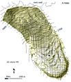
4 - Surface velocities of rock glacier Murtèl over the period 1986-96, determined by computer aided photogrammetry (left), and trajectories/surface ages computed from this velocity field (right) (after Kääb et al. 1998). |
| |
| |
|
Debris flows of highly variable size belong to the most
effective processes of debris transfer and evacuation in periglacial belts
of cold mountain areas. They usually form as a result of intense snowmelt,
heavy precipitation or outbursts of water from glacierized areas. Quantitative
estimates concerning characteristics of debris flows constitute an important
part of hazard assessments in high-mountain areas. |
|
5 - Debris flow starting zone in the Saastal/Gerental. The picture shows over steepened frozen permafrost zone in a former glacier covered glacier forefield. |
Surface inclination of starting zones on slopes and in rock gullies is generally steeper than about 25°. The largest volumes mobilized result from retrogressive erosion by water emerging at the foot of (unfrozen) talus cones or moraines (Figure 5). |
|
6 - Debris flow at the Piz Julier in the Upper Engadin Switzerland. |
Significat parts of the eroded material are usually deposited on the debris flow fans which are characterized by a rough surface topography, often including large blocks deposited. Hence, many debris flows constitute a relatively small sediment input to the main stream in the valley (Figure 6). |
|
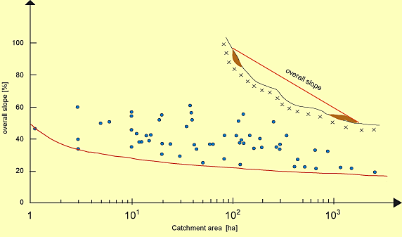
The fact that debris flow trajectories have an overall slope
greater than about 10° or 20% (path length is in most cases less than
approximately 5 times the elevation difference) can be used to estimate
maximum runout distances (Figure 7). Large flows are faster and reach
greater distances than small ones. As a consequence, relatively flat debris-flow
fans are reached by low-frequency/high-magnitude events and vice versa.
The most spectacular events usually relate to glacier floods from water
pocket ruptures and outbursts of moraine- or ice-dammed lakes. Even in
such cases, maximum volume evacuated per unit channel length usually remains
below s 500 to 700 m3. The reason for this is that formation
of a breach within morainic material with highly variable grain sizes
leads to a negative feedback, by the development of block pavements, which
protects deeper layers from further erosion. |
|
7 - Relation between average slope and the corresponding catchment area of 82 debris flows in the summer of 1987 in Switzerland |
29 August 2011 |
||
| |
||


