 |
|
|
|
|
|
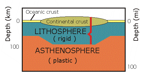
| Why are the Alps not situated further north? Why is the Himalaya so high? Which force determines the distribution and elevation of mountains worldwide? The major force behind many large-scale geologic features is the mechanism of plate tectonics. The so-called lithosphere is the strong, solid outermost shell riding on the weak, partially molten asthenosphere. The continents are raftlike inclusions embedded in the lithosphere. The Earth's lithosphere is broken into more than a dozen rigid plates which slide over a partially molten, plastic athenosphere. The continents, embedded in the lithosphere, drift along with the moving plates. If these plates collide, long mountain chains develop over millions of years, as has been the case many times throughout the earth's history. |
1 - Overview of the Earth's crust and mantle |
|
|
|
|
2 - Overview of plate boundaries |
The lithosphere is broken into many plates, which slide over the partially molten, plastic underground. There are three kinds of plate boundaries: (1) boundaries of divergence or spreading, typically ocean rigdes or rift valleys, (2) boundaries of convergence and (3) transform faults. In the following section, these three types will be discussed. |
|
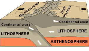
3 - Continental plates (© US Geological Survey) |
The collision of continental plates: Where two plates with continents at their leading edges converge, the crust thickens to form great mountain ranges. Examples are the Alps, where Africa collided with Europa, or the Himalaya, where India collided with Eurasia. In the case of the Himalaya, the thickness of the crust was doubled and has led to the highest mountain chain in the world. |
|
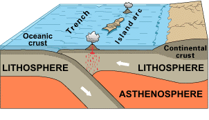
4 - Oceanic plates (© US Geological Survey) |
The collision of oceanic plates: If two oceanic plates collide, one plate tends to override the other, creating a deep trench. The Marianas trench in the Pacific Ocean was created by the collision of the fast-moving Pacific Plate against the slower moving Philippine Plate. The overridden plate is subducted and partly melts. This convergence of two oceanic plates forms chains of volcanic island arcs. Island arcs are created by the friction of subduction, which induces hot plumes of magma at the interface of the two plates. These hot plumes of magma then rise to the earth's surface and volcanoes are formed. |
|
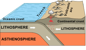
5 - Oceanic - cont. plates (© US Geologoical Survey) |
The collision of oceanic and continental plates: Where oceanic and continental plates collide, the oceanic plate is subducted, because its crust density is higher. The overriding plate is crumpled and uplifted. Deep-sea trenches (also sites of the greatest ocean depths) form along the continent. As the oceanic plate descends into the hot mantle, parts of it may begin to melt. The rock melt (magma) thus forms and floats upward, some of it reaching the surface as lava erupting from volcanoes. Overall, high mountain chains, volcanoes and severe earthquakes are associated with the convergence of oceanic and continental plates. A typical example is the collision of the Nazca plate and the South American plate, having led to the formation of the Andes. In this region, volcanoes are abundant and earthquakes frequent. |
| |
|
6 - Continental plate (© US Geological Survey) |
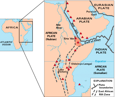
The divergence of a continental plate: If a continental plate separates, a rift valley forms. Usually, a broad area is first uplifted and the crust heated and expanded (e.g. Colorado plateau, USA). Further major rift valleys are found in East Africa and in Sibiria. In both zones, large lakes, e.g. Lake Baikal, have formed. In Europe, the Rheingraben forms a large rift system. Such rift valleys may sometimes indicate the formation of a new ocean basin. It is, however, not necessarily correct to conclude that the African Rift Valley will open to form a new ocean. The Red Sea region is a prime example of a rift valley. Three spreading centers meet at a triple junction. Two, the Gulf of Aden and the Red Sea, are actively spreading. The third, the African Rift Valley, is no longer separating and will possibly not evolve into a new ocean. What will remain on the African continent is a long, narrow sequence of trenches filled primarily with nonmarine sediment. Many lakes have formed in the African Rift Valley. |
|
7 - Oceanic plates (© US Geological Survey) |
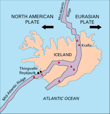
The divergence of oceanic plates: Divergent junctions in the ocean are typified by a rift, e.g. at the crest of the mid-Atlantic ridge, an underwater mountain system. This particular feature is the contact between the American plate on the one hand and the Eurasian and African plates on the other. The void between the receding plates is filled by melted material that rises from below the lithosphere. This material solidifies in the crack, and the plates grow as they separate. This process is called sea-floor spreading. The process is characterized by earthquake activity and volcanism. The mid-Atlantic ridge also crosses Iceland and the volcanic activity on this island is very high because of this. |
|
8 - Functioning of hot spots |
Hot spots: Far away from plate margins, mountains can also develop as volcanic cones. Scientists propose that hot spots are responsible for these volcanoes. These hotspots are surface manifestations of jets or plumes of hot material that rise from deep within the mantle, drill through the lithosphere, and emerge as volcanic centres. These currents are supposedly fixed in the mantle and do not move with the plates. As a result, the hot spot leaves a trail of extinct, progressively older volcanoes as the plate moves over it. The most famous example of this is the numerous volcanoes on the Hawaiian islands, formed as the Pacific plate has moved over the hot spot. In addition, the trail of volcanoes carried away from the hot spot provides an effective method of measuring the velocity and direction of plate motion. |
|
Plate Tectonic Movement Visualizations Visualizations and supporting material about plate tectonic movements Plate tectonics Download PDF-Version "This Dynamic Earth" about plate tectonics (US Geological Survey) Volcano World Follow the volcanic eruptions worldwide. Spot the Earthquakes Have a look at the US Geological Survey Earthquake Hazards Program. |
||
29 August 2011 |
||
| |
||
